Dowth is one of the three main tombs of the Brú na Bóinne World Heritage Site – a landscape of prehistoric monuments including the large passage-tombs at nearby Newgrange and Knowth.
Dowth, Knowth and Newgrange are actually all part of single ancient ritual landscape, rather than separate sites.
Unlike Newgrange and Knowth, Dowth has not been independently dated and has not undergone extensive restoration.
Dowth is less developed as a tourist attraction than Knowth and Newgrange, partly because the site has been damaged by centuries of looters, plundered by Vikings, and had stones taken by quarrying. Ill-advised archeological work in the 19th century included the Royal Irish Academy dynamiting the roof, causing a large still visible crater.
Dowth is set in a spectacular location on the highest point in the Boyne Valley. Newgrange, 2 kilometers distant, is visible from Dowth.
Dowth’s mound is approximately 15 meters high and 85 meters in diameter. It one of the largest and oldest megalithic structures in Ireland, larger than Newgrange.
http://www.carrowkeel.com/sites/boyne/dowth1.html
White quartz stones found around the base of the Dowth mound indicate it may once have had a bright white exterior wall like Newgrange.
Dowth was once surrounded by 115 kerbstones. Kerbstone 51, known as the Stone of the Seven Suns, features a number of radial circular carvings. A kerbstone with cup-marks and a spiral and a flower-like design, marks the entrance to Dowth South.
Three stone-lined passages lead into the mound. There are two passage tombs, known as Dowth North and Dowth South, and a souterrain. A third entrance on Dowth’s west side of is an early Christian souterrain that leads into the passage of Dowth North. It was built during the 10th or 11th century CE.
Like the other Boyne Valley passage tombs, Dowth has a rich mythological history.
According to one legend, Dowth is the burial place of the goddess Boann. Boann was said to have created the River Boyne.
Dowth was also believed to be the entrance to the Otherworld, a magical realm that was home to the Tuatha Dé Danann, mythical gods who lived in Ireland before humans.
In legendary lore, Dowth is called the Fairy Mound of Darkness, Dubhadh (‘darkening’), and The House of Darkness.
The medieval Dindsenchas (lore of places) says that king Bresal Bó-Díbad ordered the construction of a tower in a single day to reach heaven. Bersal’s sister cast a spell, making the sun stand still so that one day lasted indefinitely. Bresal then committed incest with his sister, breaking the spell, a legend similar to one associated with Newgrange.
With the spell broken, the sun sets and the builders leave. Hence the name Dubhadh (‘darkening’).
There may be a kernel of fact in the incest myth. Recent DNA analysis of human remains of a man at found Newgrange revealed he had parents who were most likely siblings.
These tales of light and darkness have been linked with solstice alignments at Brú na Bóinne.
Dowth’s tombs have winter solstice solar alignments like Newgrange.
Martin Brennan, author of The Stars and the Stones: Ancient Art and Astronomy in discovered the alignment during a ten-year study of the Boyne Valley.
From November to February light from the evening sun reaches into the Dowth South tomb passage and into the chamber. During the winter solstice, the sun light moves along the passage, into the circular chamber, where three stones are lit up by the sun.
https://www.knowth.com/dowth-sunsets.htm
Music:
Newgrange, RDScally & the Obstweedles, from the album Entropy: The Last Word In Everything
Available on Bandcamp
https://obstweedles.bandcamp.com/track/newgrange
ASCAP: QZ-6V5-16-00148 Published by Wounded Weasel Music Copyright 2019
Clouds Obscura, RDScally & the Obstweedles, from the album Entropy: The Last Word In Everything
Available on Bandcamp https://obstweedles.bandcamp.com/track/clouds-obscura
ASCAP: QZ-6V5-16-00156 Published by Wounded Weasel Music Copyright 2019
Entropy: The Last Word In Everything
https://obstweedles.bandcamp.com/album/entropy-the-last-word-in-everything
Published by Wounded Weasel Music Copyright 2019
The passage tomb at Newgrange is Ireland’s most famous megalithic monument.
Newgrange, located on hillside overlooking the River Boyne, 8 kilometers (5.0 mi) west of Drogheda, is a passage tomb built during the Neolithic Period, around 3200 BC. It is older than Stonehenge and the Egyptian pyramids.
Newgrange is the main monument in the Brú na Bóinne complex, a World Heritage Site that includes the nearby passage tombs of Knowth and Dowth, as well as other henges, burial mounds and standing stones.
Newgrange consists of a large circular mound with an inner stone passageway that leads to a cruciform chamber. Burnt and unburnt human bones, and possible grave goods or votive offerings, were found in this chamber.
The mound has a retaining wall at the front, made mostly of white quartz cobblestones. It is encircled by kerbstones, with many of the stones engraved in megalithic art. The mound is also ringed by a stone circle.
Some of the material that makes up the monument came from as far as the Mournes and Wicklow Mountains.
There is no agreement about the Newgrange tomb’s purpose, but it is believed it had religious significance.
It is aligned on the winter solstice sunrise so that the rising sun shines through a ‘roofbox’ above the entrance and floods the inner chamber with sunlight.
The engineering and construction of the roofbox and tomb indicates a highly sophisticated ancient culture existed in Boyne River valley.
Archeologists disagree about the construction of the Newgrange tomb.
Irish geologist and naturalist Frank Mitchell, who studied Newgrange, suggested that it could have been built in as little as five years. His estimate was based on the likely number of local inhabitants during the Neolithic age and the amount of time they could have devoted to building it rather than farming.
Mitchell’s estimate, however, was challenged by archeologist Michael J. O’Kelly and his archaeological team, who believed that it would have taken a minimum of thirty years to build.
DNA analysis revealed that bones found in the most chamber belonged to a man whose parents were first-degree relatives, possibly brother and sister. Such inbreeding was usually only found in royal dynasties headed by ‘god-kings’, such as the pharaohs of ancient Egypt, who married among themselves to keep the royal bloodline ‘pure’. The man was distantly related to people buried in the Carrowkeel and Carrowmore tombs.
This, together with the prestige of the burial, could mean that an elite group was responsible for building Newgrange.
The largely unknown Boyne valley culture used the site for about 1,000 years. The site then feel into ruins but area remained in use by the Beaker Culture, another group that replaced the culture that built the passage tomb, into the Bronze Age.
During the Bronze Age large timber circle (or henge) was constructed to the southeast of the main mound and a smaller timber circle to the west.
Newgrange evidently continued to have some ritual significance into the Iron Age. Some of the objects deposited around the mound include two pendants made from gold Roman coins of 320–337 and Roman-era gold jewelry including two bracelets, two finger rings, and a necklace. These Roman finds are interesting since the Romans did not occupy Ireland as they did Brittan and never had a long-term presence in Ireland.
Ireland’s distant past speaks to the present at Carrowmore Megalithic Cemetery.
Located on the Cúil Irra Peninsula on Co. Slio, Ireland, Carrowmore is the oldest and largest group of megalithic tombs in Ireland. It is also one of Europe’s largest megalithic cemeteries.
Thanks to extensive archeology, historic documentation, advanced scientific analysis and recent preservation efforts, Carrowmore provides a window into who the Irish of 3500 BCE were and what they were up to.
Carrowmore is set within a spectacular megalithic landscape dominated by the mountain of Knocknarea to the west. On Knocknarea’s summit is one of Ireland’s largest cairns, known as Queen Maeve’s Cairn.
There are bout 50 megalithic tombs on the Cúil Irra peninsula. Most of these, 30 tombs, are at Carrowmore.
Carrowmore’s tombs were built from 3500 BCE to 2900 BCE, during the Neolithic, New Stone Age, according to radio carbon dating results. It’s likely people who built the tombs were Ireland’s first farmers.
Carrowmore is one of Ireland’s ‘big four’ megalithic clusters along with nearby Carrowkeel in Co. Sligo and Loughcrew and Brú na Bóinne in Co. Meath.
Archaeologists consider Carrowmore – like Newgrange, Loughcrew and Carrowkeel – part of the Irish Passage Tomb Tradition.
There may have once been as many as 100 megalithic monuments in the Carrowmore area. Many of the tombs were destroyed or damaged during the during the 18th, 19th and early 20th centuries by quarrying, field clearance and by antiquarians hunting for ancient treasures.
A number of monuments are located on private property adjacent to the public National Monument.
Today Carrowmore is a protected Irish National Monument and is maintained by the Office of Public Works.
Extensive Research
Although many of the monuments have been disturbed, Carrowmore has been the subject of extensive research.
Pioneering photographers, such as W.A. Green and R.J. Welch of the Belfast Photographer’s club, photographed Carrowmore at the turn of the twentieth century.
Local landlord Rodger Walker conducted unrecorded antiquarian excavations in the 19th century. These digs were essentially treasure hunts to augment Walker’s antiquities collection. Walker kept poor records of his activities. Some of the Walker’s finds are now at Alnwick castle in Northumberland, England.
The Carrowmore monuments were mapped and numbered by Irish archeologist George Petrie in 1837 during the first mapping of Ireland conducted by the British Ordinance Survey. Petrie’s number system identifies the monuments today.
Extensive excavations led by Swedish archaeologist Göran Burenhult were conducted from 1977–1982 and 1994–1998 and 10 tombs were fully or partially excavated. Listoghil, Tomb 51, was excavated in 1996-1998.
At least two sets of archeologists have conducted extensive research on Carrowmore’s age using radio carbon dating and studies of nearby lake sediments. Carrowmore’s monuments were found to span the era from 3750 BCE to 3000 BCE and the builders were farmers.
Multimillenia-old human remains found at Carrowmore have been able to tell their story thanks to DNA analysis.
Intimate connections between occupants of other Irish passage tombs have been revealed by DNA derived from human bones found at Carrowmore. A detectable kin relationship was found between a male buried in Listoghil, Carrowmore’s Tomb 51, and three other males buried in Newgrange, Millin Bay and Carrowkeel.
This DNA relationship points to the existence of a sophisticated interrelated hereditary elite that could inspire the creation of increasingly large and complex tombs and ritual sites across a wide portion of Ireland. In a time before Stonehenge or the Egyptian pyramids, an Irish farming-based society without cities managed to use stone, bone and wooden tools to build religious monuments that have defied destruction and still retain their place in the landscape.
Modern scientific analysis of ancient genetics proves the ancestor of the people who built Ireland’s megalithic monuments originated in Anatolia, in what is now Turkey.[12]
Carrowlmore is the megalithic site keeps on giving for archeologists doing the digging.
The Sligo team conducted geophysical surveys at the Carrowmore megalithic complex, finding a circular structure that was away from where tombs have beeb found. The feature was thought to be a barrow, a circular earthen monument surrounded by a ditch.
Once the team put trowels to the soil something unexpected emerged.
IT Sligo Excavation at Carrowmore Megalithic Cemetery, May-June 2019
“Our survey revealed several features that were not visible above ground,” Bonsall said in an article in the publication Archeology. “We discovered that the ‘barrow’ contained a central pit and a substantial circular ditch.”
A sunken area within the layer of stone contained black, charcoal-rich soil, Dowd said in Arecheology.
“So far, we cannot find any parallel for it in Ireland,” Dowd said.
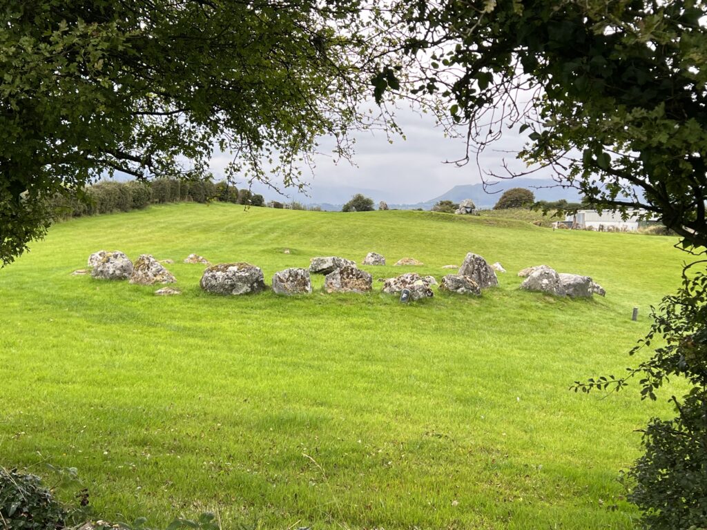
Listoghil or Tomb 51 – Carrowmore’s Focal Point
Listoghil or Tomb 51
Listoghil was built circa. 3500 BCE and is 34 metres in diameter. It the only cain at Carrowmore.
It has a distinctive box-like inner chamber.
The front edge of the entrance covering stone has marks that may be the only megalithic art at Carrowmore.
Three large boulders were found beside the central chamber. Under the cairn may be the remains of a destroyed passage or of a megalithic construction that predates the cairn.
Many of the satellite tombs face the central area. Tomb 51’s location appears to have been the cemetery’s focal point.
Unburned bones as well as cremations has been found in Listophil.
The alignment of Listoghil points at a low saddle-like formation 6.5 km to the east-southeast in the Ballygawley Mountains. The alignment coincides with sunrise at the start and the end of winter, important seasonal festivals in the Gaelic calendar.
Satellite tombs
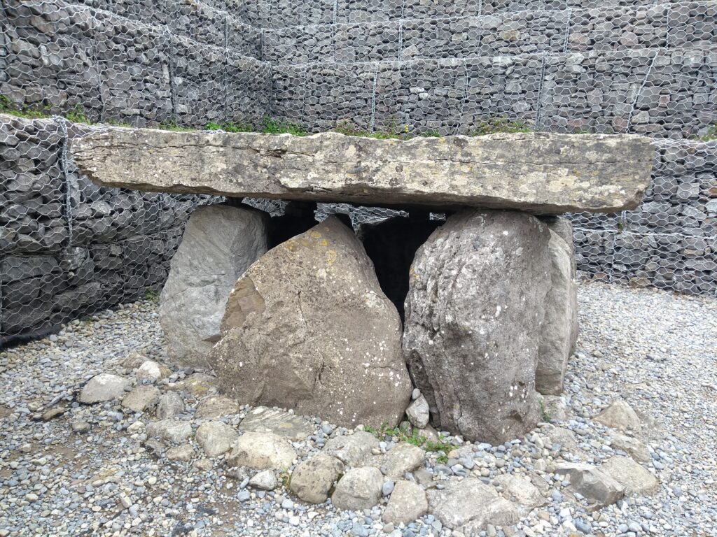
Corrowmore’s monuments originally consisted of a central dolmen-like megalith with five upright orthostat stones with roughly conical capstones on top enclosing a small pentagonal burial chamber. These tombs were each enclosed by a boulder circle 12 to 15 metres in diameter.
The boulder circles contain 30 to 40 boulders. The stone monuments are usually made with gneiss, the stone material of choice for the tombs. Some tombs have a second, inner boulder circle.
Tomb 3
Entrance stones (or passage stones, crude double rows of standing stones) extend from the central feature, showing the intended orientation of the dolmens. The monuments generally face towards the area of Tomb 51, the central cairn. Four monuments are in pairs.
Each monument was built on a small level platform of earth and stone. Stone packing surrounding the base of the upright stones that locks them in place is one of the secrets of the dolmens’ longevity.
Irish folklore dates Carrowmore’s tombs to Ireland’s mythology and the Battle of Magh Tuireadh, where the Firbolgs were defeated by the Tuatha De Danann.
Carrowmore’s ritual landscape may have taken on new meaning long after the original builders of the monuments were long gone. Archeological evidence suggests tombs that during the later Bronze and Iron Ages some tombs rebuilt and reused.
What to know if you visit Carrowmore:
Admission is 5 euro.
Open May to September 10:00 to 5:00
There’s parking lot on the south side of the road adjacent to the visitor’s center. Parking is free.
It’s worth spending a few minutes in the small museum in the visitor’s center, especially if you are visiting the site with young people.
Allow at least an hour to explore. The views of the surrounding area alone are work the walk around the site.
A two-sided, laminated map and guide to the site is available at the front desk of the visitor’s center for a REFUNDABLE 2 euro. Get the map. You’ll be glad you did.